
Wilkin County is using new technology to improve efficiency and bring information to citizens.
The county’s GIS (Geographic Information System) has undergone several improvements since it was first made available to the public in 2011.
“We’re transforming how we present information to better meet the needs of the public and to improve efficiency within the county and city departments,” County Assessor Cheryl Wall said.
GIS is a technological field that incorporates geographical features with tabular data in order to map, analyze and assess real-world problems.
In December 2016, Wilkin County signed on with Eagleview for Pictometry Imagery. The first flight was completed in April 2017 and a second flight is scheduled for 2020.
“Current aerial photography is a challenge, but necessary for dependable and quality work at the county and city level. This new imagery has been integrated into our GIS and is available within the county’s interactive mapping system for the public," Wall said.
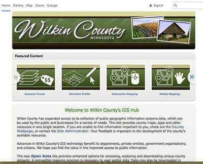
To complement the mapping system, the county has launched
ArcGIS online applications on the county website. Features which can be accessed by the public include tax parcel viewer, open data portal, assessor forms, elevation profiler, tax forfeit sales, along with mobile and standard mapping apps.
For example, to use the tax parcel viewer, citizens can locate a parcel on the map, enabling them to access the county’s current appraisal summary and tax information.
“Staff maintain parcel data so the information available remains current,” Wall said.
In the open data portal, users can search and download Wilkin County’s publicly available authoritative data such as address points, school districts and road centerlines, among others.
The apps use geographic informations systems (GIS) technology called ArcGIS Online from GIS software provider ESRI, which is designed to enable those who use it to make location data useful for performing common business tasks, she explained.
“The technology allows counties and cities to create mobile-friendly, focused and simple apps for a wide variety of functions and departments, providing citizens with better value by providing up-to-date information on mobile-friendly devices,” she said. “With this, we’re able to share data between departments and even between county and city, effectively improving workflows.”
County departments are working with Pro-West and Associates on apps to streamline their work. For example, emergency management has a damage assessment app, and can identify locations of fire departments and AEDs in the county. Law enforcement will have a 911 app for addressing needs. The Highway Department will have apps to track their road construction projects.
Wall said Pro-West has designed a very user-friendly system that’s easy to get the public and county employees engaged with.
A link for Wilkin County’s GIS Hub can be found on the county website at www.co.wilkin.mn.us and click on the “Mapping and GIS Hub” in the center of the page.
“I anticipate that it will become a valuable resource to our community, and we want to encourage everyone to visit the GIS Hub and take a look at what it has to offer,” Wall said.
For more information, contact the county Assessor’s office at 218-643-7162 or send email to GIS@co.wilkin.mn.us.