
How to Optimize Utility Asset Management with GIS
Tracking infrastructure assets such as water, wastewater or utilities is a technological challenge for smaller cities. Without the IT resources to create maps of pipelines and other linear assets, public works departments can have a tough time locating them.
At worst, technicians can cause costly damage because of inaccurate or incomplete information.
Geographic information systems (GIS) are becoming more powerful, affordable and easier to use for small local governments looking for utility asset management solutions.
GIS software has matured after decades of evolution, according to research and advisory firm Gartner, and can help with many use cases.
These include: asset management, facility mapping, real estate management, generation plant licensing support, planning, facilities design and estimation, outage management and field service. (The full report, “Hype Cycle for Utility Industry IT, 2016” by Chet Geschickter, is available to Gartner clients.)
We spoke with two experts about the key benefits of using a GIS for infrastructure asset management and tips for smaller governments to get the most out of an implementation.
Here’s what we’ll cover:
How Can Small Governments Benefit from GIS?
Popular Integrations and Implementations
What Is a GIS?
Location-based tracking gives users a way to see exactly where assets are in a facility or throughout a campus. But what about buried infrastructure assets spread across an entire city, such as water or wastewater pipes or utility distribution assets? In this scenario, accurate location data becomes much more crucial.
A GIS serves as a repository of location information and asset details, based on a web map with layers corresponding to various systems that can be updated and shared in real-time with workers in the field.
GIS platforms are gaining adoption as they become more affordable and feasible for local governments to implement.
Increased smartphone use is contributing to this growth. These personal devices are increasingly used for work, and offer a familiar, comfortable interface for GIS users, says David Totman, global water practice industry manager for ESRI, a major player in the GIS space.
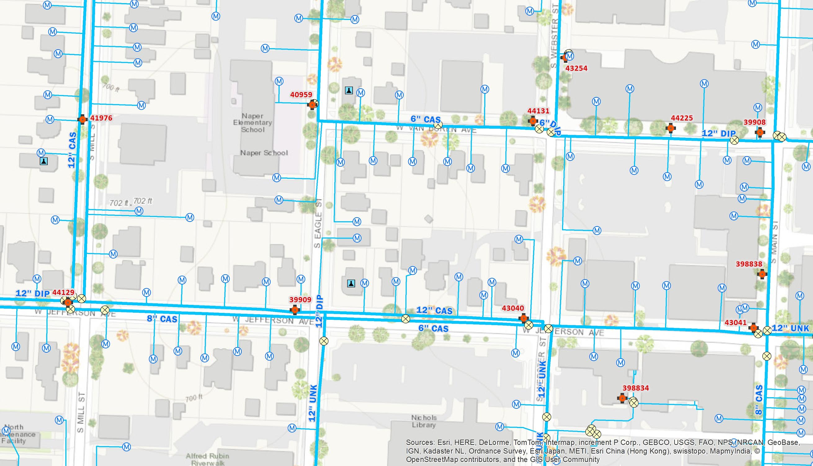
A map of a water distribution system as displayed in ESRI’s ArcGIS platform
Above, you can see a view of a web map in ESRI that shows the exact location of water pipes, their connection to buildings and details about the assets. These maps are accessible on-the-go for any worker with a web-enabled device, so crews know exactly what is under them before digging.
Next, we’ll look at the specific benefits organizations can experience using a GIS.
How Can Small Governments Benefit from GIS?
In the city of Framingham, Massachusetts, the department of public works oversees 250 miles of roadway, 200 miles of storm drainage pipe, 300 miles of water pipe and 200 miles of sewer pipe.
Director of Project Development and Right of Way Acquisition for Framingham John H. Rogers and his team track all of these systems, and manage maintenance and improvements with a GIS and CMMS platform.
In addition, he vice-chairs the Asset Management Committee in the New England Water Environment Association, which helps manage water systems that serve millions across the New England states.
“Almost all of that is made possible by programs, including GIS,” he says. “That’s the most fundamental to infrastructure.”
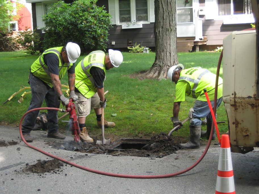
A Framingham public works crew digs to repair a catchbasin. Checking the GIS beforehand will ensure that crews do not accidentally damage the infrastructure below.
A GIS is most effective when integrated with other systems. One prominent integration is with computer-aided design systems (CAD), which create 2D and 3D images of buildings or entire towns.
Many local governments already have CAD files of their infrastructure; by plugging this CAD file into a GIS, cities can build an evolving repository of locational data, available to any worker.
In Rogers’ department in Framingham, the system is also connected with VUEWorks, an EAM system that links GIS data with work order creation.
“That’s what’s used day-to-day,” Rogers says. “It’s an EAM that allows us to generate work orders for guys out in the field to fix pipe or investigate issues or clean, and also, if done right, collect work order history.”
Combined, the GIS and EAM platforms give the city’s public works department the ability to track every linear foot of pipe and roadway, locate issues and assign work orders, as well as perform analysis—the Framingham department can answer key questions that help them make smarter decisions:
In which area of the city do we spend the most money cleaning the sewers? Why?
Are the pipes that most often break of a certain diameter or material?
We’re planning to replace water pipes in this area. Is there an easement here?
As mentioned before, the use of mobile devices increases the efficiency of a GIS platform. Rogers’ team can refer to the web map and asset information using rugged laptops, tablets or smartphones anywhere their jobs take them.
These field data collection tools help reduce the time needed to travel back and forth between the worksite and the office, Totman from ESRI says. In addition, they offer real-time information on-the-go, a channel of communication among the team and the ability to add details about assets from anywhere.
To recap, here are some core capabilities and benefits of a GIS and EAM platform:
GIS/EAM Platform Capability | Benefit |
Track all infrastructure assets | The GIS is a system of record for all of your infrastructure assets. Users can search for specific assets to add or edit details. |
Generate work orders | When coupled with a GIS, work orders created in a CMMS or EAM system can automatically fill in the location data for workers so that every job is performed in the correct location. |
Improve routing of workers | When dispatching technicians for emergency work, it’s important they get to the job site quickly. Many GIS vendors offer functionality to help determine the quickest route for fleet vehicles. |
Real-time, shared web map | Workers in the field can use mobile devices or laptops to view a web map to confirm they’re at the correct location or look up details about infrastructure before starting. Offline maps enable users to access information without a connection, and automatically sync updates when the connection returns. |
Analysis and reporting | Create custom reports within the GIS or the CMMS/EAM to identify which types of pipes break most often, which areas of the city generate the most work orders and more. |
Totman says these capabilities are now available in affordable suites. And in ESRI’s case, they’re increasingly easy to use. The company has adopted a “three clicks or less” policy to ensure any user on the team can access the information they need quickly.
“Rural water systems are the ones starting to face the same regulation mandates that their bigger brothers are facing, but they don’t have enough funding, and they have limited IT resources,” he says.
“That’s why we’ve adopted a new mantra of being easier to use and more cost effective, and we have packages that are quite affordable for small utilities.”
Popular Integrations and Implementations
Besides CMMS, EAMs and CAD files, a GIS is able to integrate with several other systems to maximize the efficiency and functionality of the platform. Here are some other useful integrations:
Automated Vehicle Location (AVL): AVL systems use GPS to track the exact location, speed and direction of fleet vehicles. Totman says AVL integration is useful when “trucks are out there in the field, and you have an emergency event. You want to dispatch the closest crew with the right skills and materials for the job,” he says.
Customer Information System (CIS): A CIS helps manage the metering and billing processes accurately.
Supervisory Control and Data Acquisition (SCADA): A type of industrial control, a SCADA system enables remote monitoring of assets. This helps avoid costly repairs by feeding real-time condition data back to the larger platform so workers can address problems before they occur.
Social media: One of the newer data feeds, Totman says, is the ability to track the location of any tweets on a map using the GPS on customer smartphones.
Totman says he instructs small governments to educate their communities about using hashtags on Twitter. For example, residents can tweet a photo of a pothole with “#pothole.” If you get several citizens tweeting the same thing, it’s a good indication that you should dispatch a crew.
It’s even possible to automatically generate a work order if enough of the same hashtag occurred in the same area. Totman says these are quite affordable options for smaller governments.
“Social media is becoming a great tool to enable citizen sensors,” he says. “Your community is out there; why not use them as your eyes and ears?”
For those governments or utilities who are interested in implementing a GIS platform, Totman and Rogers also offer some tips to make it a smoother process:
What do you need the tool to do? As with any investment, organizations need a goal they want to achieve with the tool—determine your benefit. “You don’t need the grand scale enterprise asset management tools, but you have to get started,” Totman says. Start small, and the benefits will grow as your team adds information over time.
What do you need to achieve that goal? The second question to answer for any investment: Does your organization have what is needed to utilize the tool in the most effective way?
Rogers says the town of Framingham implemented a GIS, but didn’t see evolutionary improvements until they added the EAM about ten years ago. He identified three key factors to making that new system work:
Time to implement the system and train workers.
Financial commitment for staff pay, extra computers or other hardware.
Departmental commitment to add to the asset registry over time.
“It’s not perfect and there’s constant change in the community,” Rogers says. “It can take a long time to get that GIS inventory put into the system, perform quality control and edit as needed.”
Identify your source data. Find out where your existing data lives; maybe it’s on a physical map, Totman says, or simply in an employee’s head. Either way, determine the best way to get that data into a spreadsheet.“Many have CAD and a lot of spreadsheets,” he says. “There is a lot of good information in spreadsheets that can easily be mapped with an address or longitude and latitude data. We can put it on a map.”
Start with baby steps when entering data. The GIS comes with base maps, and you can start adding information immediately. However, Totman recommends starting small and collecting data broadly.
“You should collect minimal information for each asset to help make decisions, but you should broad brush the entire system, and you can evolve over time as events happen,” he says.
As work on infrastructure continues, there will be opportunities to add information, and over time, you can deepen the data collected for each asset.
Conclusions
As a small governmental organization, any new software investment can be daunting. But as long as you have a goal in mind, start collecting basic information and commit to developing the asset registry over time, your public works team will have an invaluable data system to make quick, accurate decisions.
Next Steps
GIS platforms can be customized in ways that help you tackle infrastructure repairs and improvements more efficiently. Here are some next steps you can take to learn more:
A major aspect is the CMMS or EAM that incorporates the locational data. Take a look at reviews and ratings for maintenance management and enterprise asset management software to find one that meets your needs.
Read about how a CMMS can help solve problems specific to small organizations, and learn about the best maintenance apps that give your workers the asset and locational data they need while in the field.