Idaho Fire Info Idaho Fire Map Near Me
Idaho has a surprisingly large number of active fires right now. The state has 10 fires, numbering 17,963 acres total. Read on for more details on where these fires are, their containment levels, and maps.
You can see a fully interactive map of the fires in Idaho here, as provided by Idaho Fire Info. A map on Idaho.gov’s page does not appear to be updated. But the following map, powered by ESRI, also contains information on the situation in Idaho. Zoom in for more specific details or visit Idaho Fire Info’s map at the link above.
Here’s another map from the Bureau of Land Management:
Large fire activity for @BLMIdahoFire from recent lightning storms. For the most current fire update please following here on Twitter or Idaho Fire Info webpage and Facebook! #fireseason18
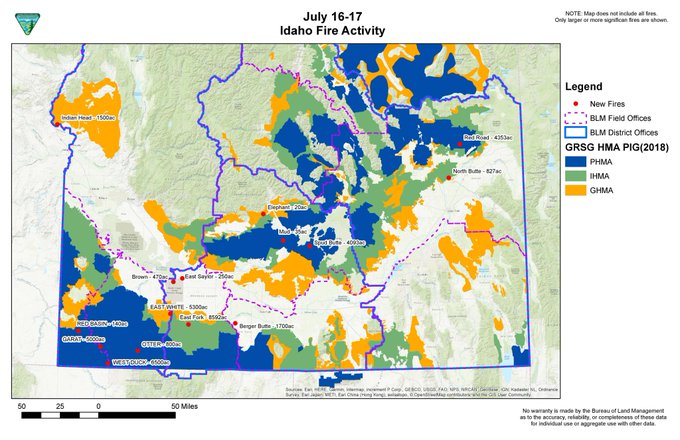
Here are details on the fires in Idaho as provided by NIFC and other sources.
Berger Butte Fire
This fire in South Idaho is 1,700 acres and 80 percent contained. It’s located 12 miles south of Buhl and seven miles southeast of Castleford. But by Monday night it was listed as contained.
Brown Fire
This fire is being managed by the Department of Defense, as it’s located on the Mountain Home Air Force Base. It’s 470 acres and 90 percent contained, located 10 miles south of Hammett. It’s expected to be fully contained by tonight, KMVT reported.
East Fork Fire
#EastForkFire grew to 6,000 over night. Crews are facing difficult terrain, high temps, low humidity, and gust winds today. BLM camp crew and additional resources have been ordered. #BLMTFDFire
This fire in South Idaho is 4,000 acres and 0 percent contained (but a more recent map updated on July 16 indicates that it’s 8,595 acres and 0 percent contained.) It’s 33 miles southwest of Twin Falls and 26 miles southwest of Castleford.
Two of the lightning-caused fires near Castleford have burned an estimated 10,400 acres. #wildfire #brushfire #eastforkfire #bergerbutte #SpudButteFire #ElephantFire #BLMTFDFire t.co/DMbYgu8Oc9
East White Fire
We are en route to the #EastWhiteFire which is burning along the Bruneau River in SW Idaho.
This fire is 1,000 acres and 10 percent contained. (But a report from July 15 indicates it may be 5,300 acres and 10 percent contained.) It’s 30 miles southeast of Owyhee.
Garat Fire
This fire is 1,300 acres and 0 percent contained. (But a report from July 15 indicates that it’s 5,000 acres and 0 percent contained.) It’s 20 miles west of Riddle.
Lodgepole Fire
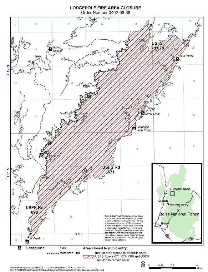
InciwebLodgepole Fire Map
This fire is 1,600 acres and 25 percent contained. It’s 16 miles northeast of Garden Valley, 14 miles north of Crouch along National Forest System Road 671. Originally a prescribed burn, it was changed to a wildfire in order to allow for more competitive resources to be used to fight the blaze.
MM21 Hwy 22 Fire
This fire reached 685 acres, but it is now 100 percent contained.
Mud Fire
This fire, caused by lightning, grew to 55 acres and was about 12 miles north of Richfield. It was contained by noon Tuesday and is expected to be under control by Thursday evening, KMVT reported.
North Butte Fire
This fire reached 827 acres but is now 100 percent contained.
Otter Fire
This fire is 400 acres and 0 percent contained. It’s six miles east of Riddle.
Red Road Fire
This fire, updated on July 16, is 4,353 acres and 0 percent contained. (It’s unclear if this might be the same as another fire on this list or a different fire.)
Spud Butte Fire
Two of the lightning-caused fires near Castleford have burned an estimated 10,400 acres. #wildfire #brushfire #eastforkfire #bergerbutte #SpudButteFire #ElephantFire #BLMTFDFire t.co/DMbYgu8Oc9
This fire is 4,093 acres and 70 percent contained. It’s nine miles southeast of Carey and was listed as contained by Monday night, and expected to be under control by Wednesday evening, KMVT reported.
#SpudButteFire was contained last night (7/16) at 9 p.m. with a control set for tomorrow (7/18) at 8 p.m. no active fire, resources remain on scene monitoring and mopping up hot spots. #BLMTFDFire
West Duck Fire
This fire is 3,000 acres and 0 percent contained. It’s 15 miles southwest of Riddle.
This is a developing story.