Thursday, August 10, 2017
Esri Teams To Use Drones To Help Fight Wildfires
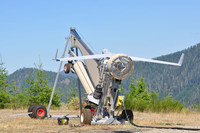 Redland-based GIS technology and software provider Esri is helping to power a new product, which is using military drone technology to help fight wildfires. According to FireWhat, Esri, and unmanned aerial vehicle maker Insitu, they've created a system for aerial reconnaissance of wildfires. The system taps Insitu's ScanEagle aerial vehicle, Esri's geographical information systems (GIS), and support from FireWhat's fire professionals, to help provide data collection and spatial analytics of fires. According to the companies, their system provides imagery from military-grade electro-optical (EO) cameras during daylight, and infrared (IR) cameras for nighttime imaging, helping to fill the gap in information for fire incident commanders in near real time. The companies said the new system reduces the typical 12-to-24 hour information lag time seen on fires today.