

Never Miss a Beat: Get a snapshot of the issues affecting the IT industry straight to your inbox.
SpaceCurve takes on Oracle and other database vendors with a geospatial platform that brings location analytics to streaming apps.
4 Min Read

2014 In Space: 11 Major Achievements
2014 In Space: 11 Major Achievements (Click image for larger view and slideshow.)
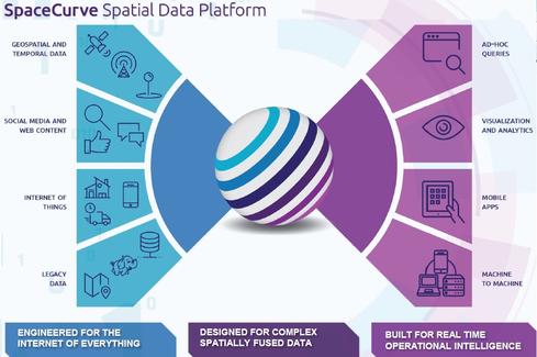
It's already quite difficult to make sense of location- and time-based data from mobile phones, fleet telemetry systems, GPS devices, and other sensors. The expected wave of connected home devices, smart-city sensors, and Internet-of-Things-style applications will make a fast and highly scalable geospatial platform a must.
So says SpaceCurve, a Seattle-based startup that on Tuesday introduced a platform designed to spatially organize and analyze machine-generated data sources in real-time at extreme scales, according to the company.
SpaceCurve's founder, J. Andrew Rogers, has experience in the domain, having previously led development efforts on the large-scale analytic and geospatial system that became Google Earth. Rogers formed SpaceCurve to develop a geospatial database that supports real-time analytics.
[Want more on geospatial insight? Read Urban Observatory Maps Comparisons Between Cities.]
"We can bring a variety of information into a unified geospatial model and ... pull it out quickly without performance- and cost-intensive table scans," said Dane Coyer, SpaceCurve CEO, in an interview with InformationWeek. "We also support concurrent data-ingest and querying without ... batch-processing delays."
The scale and speed promises are extreme, and the company is ambitiously going up against popular vendors, including Oracle, that have added geospatial support to their widely used relational databases.
"Oracle can do spatial operations on data, but they have some fundamental limitations with their architecture," said Coyer. "SpaceCurve can operate on streaming data that's coming in at millions of records per second, store it, and make it immediately available for downstream analysis"
SpaceCurve isn't trying to go it alone. It has partnered with geospatial applications giant ESRI, which has integrated its popular ArcGIS server with SpaceCurve. ArcGIS serves as a front-end analytics interface for geospatial analysis and visualization of the data managed in SpaceCurve (the product).
Another partner is AirSage, a company that collects antenna and de-identified mobile-device data from major mobile carriers. It then adds census block data, road data, transportation-network data, weather data, and other sources to develop location intelligence about transportation patterns, aggregated demographics, and more.
"AirSage can show operators of resorts, arenas, and large entertainment complexes where people are coming from, where they're going, and where they stop along the way," Coyer explained. Anonymous mobile devices, including mobile phones, tablets, and even smart cars, are the sensors used for this location intelligence.
Where beacons and WiFi geofencing systems can see localized patterns inside buildings, AirSage is using SpaceCurve to analyze and aggregate high-scale data spanning large, outdoor areas collected across multiple networks.
"The sports stadiums here in Seattle are all near each other, and there are many destinations around them, like bars and restaurants and stores, and people get there using various modes of transportation," Coyer explained. "AirSage can look at the socioeconomic makeup of people passing by, say, a particular retail location at certain times of the day."
Early customers of SpaceCurve include Socrata, a provider of open-data management systems and apps for government agencies; Dyn, an Internet-performance monitoring and analysis service; and Via Informatics, a crowd-sourced location-intelligence company.
"By providing the ability to geospatially index streaming data and query millions of records quickly, SpaceCurve provides us a cost-effective way to manage the diverse streams of data used in our analytics processes," said Mossab Basir, co-founder and CEO of Via Informatics, in a statement from SpaceCurve.
SpaceCurve says its platform will appeal to businesses that have always been location sensitive, such as transportation, logistics, and telecommunications firms. It will also appeal to "new-breed companies," such as AirSage, Socrata, Dyn, and Via Informatics, that are managing, aggregating, enriching, and, in some cases, reselling mixes of sensor and geospatial data.
"In the future we expect to package up a [cloud-based,] per-use offering, but currently we're working on the software-licensing model," Coyer said.
Apply now for the 2015 InformationWeek Elite 100, which recognizes the most innovative users of technology to advance a company's business goals. Winners will be recognized at the InformationWeek Conference, April 27-28, 2015, at the Mandalay Bay in Las Vegas. Application period ends Jan. 16, 2015.
About the Author(s)
You May Also Like
More Insights
Webinars
Editor's Choice


May 2, 2024
While there are plentiful options in cyber resiliency and business continuity tools and platforms, there isn’t one that can knock out everything from sudden cloud outages to prolonged ransomware attacks in a single punch. What can you do to keep the company on its feet no matter what is thrown at it? Find out in this new virtual event.
Reserve Your Seat Now