
 Yahoo News
 Fascinating interactive map shows exact geography of sprawling TfL and Tube network
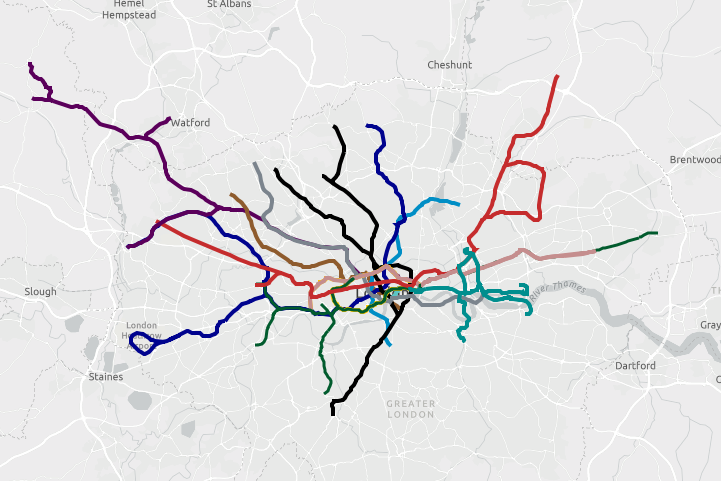
A fascinating new interactive map reveals the exact geography of Transport for London's sprawling Tube, Overground and DLR network.
The iconic Tube maps used by TfL today were originally the brainchild of Underground electrical draughtsman Harry Beck who based his diagrams on the the order of stops rather than the exact geographical route.
But now a team of developers at mapping and analytics company Esri UK have worked together to create an interactive map that shows the real geographical locations for all the lines.
It charts the winding routes of the London Underground, DLR and Overground and also reveals which parts of the network are above and below ground.
The tool features a slider that allows users to move between the two functions.
Swipe left and you will be able to see precise details of routes, including the differing lengths of each line - with some reaching far beyond the city.
Lines are colour coded according to the original Tube map - the Central line is red, for example.
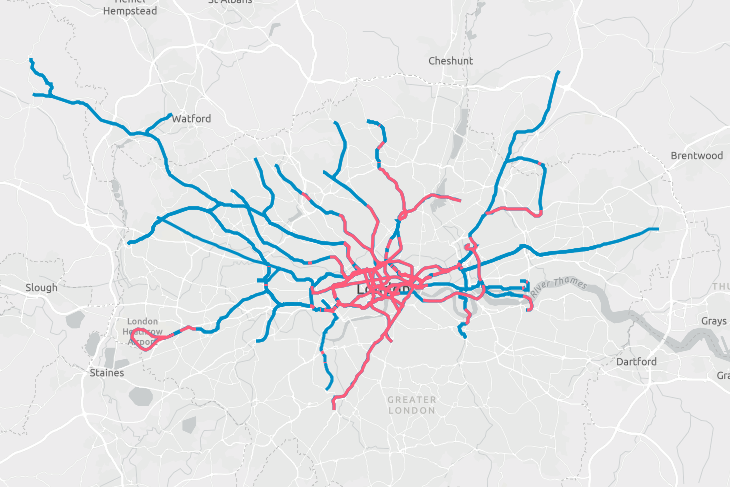
Swipe right and you will see which parts of the network are above or below ground.
The parts highlighted in pink represent underground, and blue shows overground.
Experts at Esri UK claim that nearly 80 per cent of the 250-mile TfL network is above ground.
According to researchers, just 52 miles of routes lie underground, with the Waterloo & City line being the only line completed submerged below the capital.
More than 90 per cent of the Victoria line is underground, the analysts claimed.
While 86 per cent of the Metropolitan line runs above ground, they added.
Mr Beck, an Underground electrical draughtsman, based the Tube map on the circuit diagrams he drew for his day job.
The map was initially rejected by the publicity department because it was considered too radical, but was taken up after a successful trial print-run.

