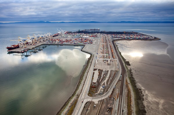
Roberts Bank Terminal 2 is a planned addition to one of the Port of Vancouver's major hubs of shipping traffic, built on an artificial island off the southernmost B.C. coast. The preliminary design assumes that, despite rising sea levels, storm activity will not change much. But simulations by The Globe and Mail show a one-in-500-year storm today could overwhelm much of the busiest Vancouver port facilities.William Jans Photography/Vancouver Fraser Port Authority
Graphics by Murat Yükselir
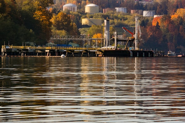
Roberts Bank defies that old adage about land – that they’re not making any more of it. This artificial island was built in the late 1960s for a coal terminal and is joined to British Columbia’s southernmost coast by a four-kilometre causeway stretching into the Strait of Georgia.
The island expanded as the Port of Vancouver struggled with a dearth of available industrial land across British Columbia’s densely populated Lower Mainland region. Today, midnight-black mountains of coal share the island with Deltaport, a sprawling container terminal that has berthed some of the world’s largest vessels.
It is about to double in size yet again. The Vancouver Fraser Port Authority proposes to add a new appendage to the island that will be 1.7 kilometres long and 700 metres wide made out of concrete caissons and nearly 18 million cubic metres of rock, gravel and compacted sand. Roberts Bank Terminal 2 is intended to “remain in perpetuity,” according to a document that describes the project.

ROBERTS BANK TERMINAL 2 PROJECT
Vancouver
Richmond
Delta
DELTA
Proposed Roberts Bank Terminal 2
Existing Roberts Bank Terminals
THE GLOBE AND MAIL, SOURCE:
PORT OF VANCOUVER

ROBERTS BANK TERMINAL 2 PROJECT
DELTA
Proposed Roberts Bank Terminal 2
Existing Roberts Bank Terminals
Vancouver
Richmond
Delta
THE GLOBE AND MAIL, SOURCE: PORT OF VANCOUVER

ROBERTS BANK TERMINAL 2 PROJECT
DELTA
Proposed Roberts Bank Terminal 2
Existing Roberts Bank Terminals
Vancouver
Richmond
Delta
THE GLOBE AND MAIL, SOURCE: PORT OF VANCOUVER
But submerged deep within regulatory documents is a reason to wonder whether that statement amounts to pure engineering hubris. The world’s oceans have been rising for the past century and a half, and scientists predict this imperceptible upward movement will accelerate as the planet continues to warm up and its great ice caps in Greenland and Antarctica melt. The terminal’s preliminary design anticipates a rise of 50 centimetres by 2100; it assumes that storms, and the waves and flooding they bring, will not change much. “Sea level rise is not expected to adversely affect the Project over the long term,” one document asserts.
The federal environment department challenged that assumption during the environmental review process. A major danger is storm surge, which is rising seawater caused primarily by high winds. “Future storm surges will be affected by changes in storm intensity and local sea level, which is projected to rise in the region and consequently to result in larger storm surges,” it noted in a submission in November, 2017. “Assuming that future storms will be within the envelope of the past ignores the additional uncertainty associated with climate change.”
The port authority had heard such warnings before. In 2013, it received a report from a technical advisory group that considered potential sea level rise at Roberts Bank. The lowest scenario considered in that report was 50 centimeters of sea-level rise over the next century. The medium projection was one metre, and the highest scenario was a devastating 2.2 metres. It also warned that existing projections may underestimate the impact of factors such as Greenland’s melting ice cap, and the ocean’s tendency to expand in volume as it warms.
But all that’s decades off. The more immediate concern is keeping up with surging trade volumes throughout the Pacific Rim. Last year, shippers experienced serious delays at Canada’s West Coast ports, raising doubts about whether they can handle increases in shipping traffic. The Port of Vancouver is building and upgrading facilities to relieve the pressure. According to InterVISTAS, a consultancy that produces regular reports for the port authority, capital spending on port facilities is expected to reach more than half a billion dollars each year during the next decade. Roberts Bank Terminal 2 alone is anticipated to cost more than $2-billion.
In addition to managing its own facilities, the port authority is landlord for many privately leased port lands. A joint venture is building a new grain export facility called G3 Terminal Vancouver in North Vancouver. Further east along Burrard Inlet, Trans Mountain (a subsidiary of energy transportation giant Kinder Morgan Canada Ltd.) is constructing three new berths at its Westridge Marine Terminal as part of a major expansion that would triple the capacity of its pipeline. The project’s future has been cast in doubt by a dispute among multiple levels of government, much of it concerning how the Alberta crude it will carry will contribute to climate change and other environmental problems.
These projects have something in common: Proponents have assumed sea-level rise will be on the low range of current projections. If they have underestimated the Pacific Ocean, those facilities could be condemned to a future of regular flooding, extensive damage and costly service interruptions.
The implications would be felt far beyond the Vancouver area. According to the International Maritime Organization, more than 90 per cent of the world’s traded goods are transported by sea. The Port of Vancouver moved 142 million tonnes of cargo last year, a record high. This included massive quantities of coal and grain, wood pulp, logs, steel, Korean and Japanese cars. A few million shipping containers, their contents diverse beyond comprehension, flow in both directions every year.

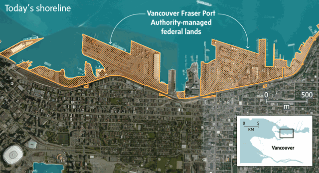
VANCOUVER FRASER PORT AUTHORITY (VFPA)
VFPA-managed federal lands and waters
Terminals and port lands
Municipal boundaries
West
Vancouver
North
Vancouver
Anmore
Coquitlam
Port
Coquitlam
Burnaby
Vancouver
Surrey
Richmond
Delta
0
10
KM
MURAT YUKSELIR / THE GLOBE AND MAIL,
SOURCE: VFPA

VANCOUVER FRASER PORT AUTHORITY (VFPA)
VFPA-managed federal lands and waters
Terminals and port lands
Municipal boundaries
West
Vancouver
North
Vancouver
Anmore
Coquitlam
Port
Coquitlam
Burnaby
Vancouver
Surrey
Richmond
Delta
0
10
KM
MURAT YUKSELIR / THE GLOBE AND MAIL, SOURCE: VFPA

VANCOUVER FRASER PORT AUTHORITY (VFPA)
VFPA-managed federal lands and waters
Terminals and port lands
Municipal boundaries
West
Vancouver
North
Vancouver
Anmore
Coquitlam
Port
Coquitlam
Burnaby
Vancouver
Surrey
Richmond
Delta
0
10
KM
MURAT YUKSELIR / THE GLOBE AND MAIL, SOURCE: VFPA
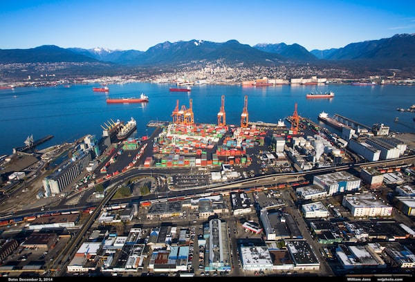
A port facility in Burrard Inlet, in between Vancouver (foreground) and North Vancouver. The inlet is home to a growing array of shipping centres, like the new G3 grain-export facility and Trans Mountain's Westridge Marine Terminal.Vancouver Fraser Port Authority
SEA CHANGE: ABOUT THE SERIES
The world’s oceans have been rising in lockstep with global temperatures since the mid-1800s – and the pace is accelerating. In this five-part series, Sea Change, The Globe and Mail examines how Canada’s most vulnerable coastal communities are preparing for an inexorable force that will reshape their coastlines – in potentially catastrophic ways – for generations to come.

0
10
Coastal sensitivity
to climate change
KM
Low
Medium
High
B.C.
Vancouver
MURAT YUKSELIR / THE GLOBE AND MAIL,
SOURCE: CANCOAST

Coastal sensitivity
to climate change
0
10
KM
Low
Medium
High
B.C.
Vancouver
MURAT YUKSELIR / THE GLOBE AND MAIL,
SOURCE: CANCOAST

Coastal sensitivity
to climate change
0
10
KM
Low
Medium
High
B.C.
Vancouver
MURAT YUKSELIR / THE GLOBE AND MAIL, SOURCE: CANCOAST
PART 5: VANCOUVER
Population: 2,463,431
Projected sea-level rise by 2100: 44 cm to 62 cm
WHAT THE SCIENCE SAYS
Read Matthew McClearn's primer on the science behind this series.
Conflicting perspectives
The Port of Vancouver is comprised of 28 major marine cargo terminals and two cruise ship terminals dispersed among pockets of land stretching from Burnaby to Delta. Nobody knows how much all of those facilities are worth. One-quarter of port tenants responded to a recent port survey asking for the replacement cost of their fixed capital, and the sum came to $9.3-billion.
To assess the danger rising seas could pose to these facilities, The Globe and Mail examined flooding scenarios for the Port of Vancouver using ArcGIS, a geographical information system (GIS). We used data provided by the Fraser Basin Council, which simulated a storm surge with a return period of 500 years − that is, a storm with an estimated 0.2 per cent chance of occurring in any given year. Although a storm of that magnitude would by definition be considered extreme, climate change is expected to make such storms far more frequent by the end of the century. Kerr Wood Leidal, an engineering consultancy hired by the council, recommended that 1-in-500-year coastal flooding should be the minimum standard when assessing the vulnerability of heavily populated areas like Vancouver.
Steve Litke, the council’s senior program manager, noted that the simulated flooding ignores wave action and assumes water levels would be uniform. An actual storm’s effects are far more complex.
Our simulations showed a one-in-500-year storm today would inundate much of the Lower Mainland’s port lands, including some of its busiest facilities. Add to that the one metre of sea-level rise anticipated by 2100, and most major port facilities would be under water.
Source: Fraser Basin Council
So far, flooding has not been much of a problem for Vancouver’s port. Unusually high tides that occur naturally – known colloquially as “king tides” − have become a minor nuisance. Port Authority spokesperson Danielle Jang noted two recent small floods affected a low-lying parking lot and two sites along the Fraser River, creating some traffic and parking challenges. “To date, we have not had to actively deal with flooding situations,” Ms. Jang wrote in an e-mail.
And in stark contrast with ports on the Atlantic coast and the Gulf of Mexico, hurricanes and tropical storms are virtually unheard of in Vancouver. The culprit in the region’s two benchmark floods (in 1894 and 1948) was the Fraser River.
But that is likely to change. Not only are rising sea levels expected to increase the frequency and magnitude of coastal flooding greatly, but higher ocean waters could also cause rivers and streams in the lower reaches of the Fraser Valley to back up. “We can expect bigger and more frequent flood events, both on the coast and the river,” Mr. Litke said.
Vancouver’s problem is compounded because large river deltas tend to sink. A 2009 paper from the Geological Survey of Canada asserted that sediments in the Fraser River delta are slowly compacting, causing much of the land in the Vancouver area to subside at a rate of one or two millimetres a year. Large structures in the Fraser River basin – including Roberts Bank – sink faster.
There are many conflicting perspectives on what future flooding in Vancouver will look like. The port authority’s land-use plan contemplates sea-level rise of 20 to 60 centimetres by 2114. The B.C. government, by contrast, recommends preparing for a full metre by the end of this century. Some port authorities are more cautious. “Rhode Island’s guidance is for two metres by 2100,” said Austin Becker, a professor of coastal planning, policy and design at the University of Rhode Island. “I think one metre is pretty low at this point, for anywhere.”
Project proponents seem to be following the port authority’s lead. Although neighbouring municipalities urged G3 to build its new grain terminal to their standards, G3 adopted the port authority’s guidance, which was a half a metre lower.
Trans Mountain, meanwhile, turned to a 2008 paper by the federal Department of Fisheries and Oceans that predicted local sea levels will climb 20 to 30 centimetres by 2100. It based its design on DFO’s extreme-high scenario – half a metre. Flooding is “not anticipated to be an issue” at the terminal, according to a document the company filed last year to the Port Authority as part of the project’s review process.
But Rick Thomson, the DFO research scientist who wrote the paper, said those projections are outdated. (He published updated estimates in 2012.) That would not be worrisome if Trans Mountain intended its facility to last only to mid-century; most forecasts say much of the change in sea level will happen late in the century. But if Trans Mountain wants its terminal to last that long, it might want to update its projections. “For the next 100 years, we were being conservative,” Mr. Thomson advised. “If you really want to push it, you should be considering one to two metres.”
Trans Mountain said in a statement that it expects the 50-centimetre allowance should “be adequate for the very long term.” And if it is not, “future adaptive measures will be considered.”
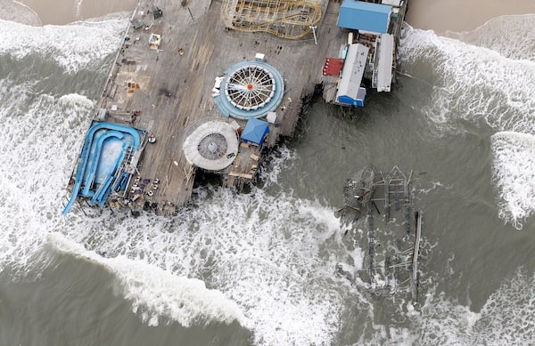
Oct. 31, 2012: An aerial photo shows the destroyed Casino Pier in New Jersey's Seaside Heights, days after Hurricane Sandy wreaked havoc on the Jersey Shore. Sandy offered lessons about the results of a destructive storm on ports, such as wrecked electrical systems, mechanical failures and hazardous waste.ANDREW MILLS/The Star-Ledger
‘The research phase’
A severe storm can wreak havoc on a port. On Oct. 29, 2012, Hurricane Sandy directly struck the ports of New York and New Jersey. Thomas Wakeman, a transportation professor at the Stevens Institute of Technology in Hoboken, NJ, spent much of his career working on port infrastructure: He helped New York and New Jersey with dredging challenges in the 1990s, and in early 2004, he helped reopen Iraq’s ports after the 2003 invasion. Now an educator, he studied Sandy’s aftermath and published a report in 2013.
“Water does a lot of things we didn’t anticipate – particularly when you’ve got four to 12 feet of it over your facility,” Prof. Wakeman said. “It screwed up all the electricity, it made a bunch of electric cars burn up. It mixed the water and waste water so you had a hazardous-waste problem. It knocked out all the power for communications. It made a mess.”
Saltwater ruined ship-to-shore crane motors, tractor trailers and train brake systems. Power failures took nuclear-detection portals offline, meaning cargo could not be screened in accordance with federal regulations. They also knocked out traffic signals and overhead lighting required for night operations. It took weeks to re-establish port operations. Such prolonged interruptions force a port’s customers to redirect their supply chains. The lost business may never be recovered.
Every port, and every storm, is unique, but Prof. Wakeman argued some lessons from Hurricane Sandy are broadly applicable. For starters, buildings, electrical systems and workers’ offices should be moved to higher elevations, his report said, and building codes and standards should be updated.
Some ports are already responding. The Port Authority of New York and New Jersey published engineering guidelines for the construction of new projects. The Massachusetts Port Authority introduced a flood-proofing design guide aimed at minimizing damage to crucial facilities.
The Port of Seattle, 200 kilometers south of Vancouver, has drafted a climate-change adaptation plan. That plan proposed filling in low-lying land vulnerable to flooding, and discussed upgrading stormwater systems that are at risk of backing up at times of high water. The port authority has also considered how capital projects should be designed to make them more resilient in the face of rising sea levels.
The Vancouver Fraser Port Authority has yet to do any of those things.
Its lands are technically under federal jurisdiction. But Sean Smith, a Port Authority engineer, said projects that are in planning or construction today largely conform to the regulations of neighbouring municipalities. The port’s jurisdiction borders 16 municipalities, and their requirements vary considerably. For example, the City of Port Moody’s zoning bylaw requires structures be built at least 1.5 metres above “the natural boundary of the sea.” The City of Vancouver recently updated its bylaws to increase minimum construction elevations in areas vulnerable to flooding by about one metre.
“At this point, we don’t really have any guidelines that we’ve set for ourselves,” Mr. Smith said. “We’re still in the research phase, trying to figure out what would be appropriate for us.”
Port facilities in Burrard Inlet. As a 'landlord port,' where private operators run their facilities over three- to five-decade agreements, port authorities are limited in what they can do on their own to guard against future climate change.Melissa Tait/The Globe and Mail
But the port authority’s approach could evolve considerably over the next few years. It is surveying its lands with LiDAR, a technique that uses laser pulses to create detailed topographical data. The data are used to draw up flood maps identifying the facilities most at risk. It also plans to form a new team this year to study the effects of climate change, including rising sea levels. Although its mandate has yet to be determined, Mr. Smith said it could conceivably result in the port adopting its own flood-construction levels and other measures.
The port is among dozens of agencies and municipalities across the region involved in the Lower Mainland Flood Management Strategy, an initiative led by the Fraser Basin Council that seeks to co-ordinate adaptation measures.
‘The future is tomorrow’
There are broad strategies for responding to uncertainties about future sea levels. Paradoxically, one is to think short-term.
Major port infrastructure, such as docks and port terminals, is often built to last half a century or longer. Some argue it’s now sensible to plan to rebuild facilities more often as sea levels rise, rather than investing tremendous sums based on assumptions that could be mistaken. “Instead of designing for the next 80 years, you design instead for 35,” Prof. Wakeman said. “When I’m in the dark and I’m trying to feel my way around, I take smaller steps than I do in bright sunlight.”
That, in a nutshell, is the Port of Seattle’s philosophy. It’s betting that significant sea-level rise will not occur until about 50 years from now. “Fifty years is the longest design life that we assign to any of our assets,” said spokesman Peter McGraw. “We would be replacing those assets, and raising them theoretically, before sea-level rise would inundate them.”
Another approach is to leave room to erect future seawalls and other defences. And while no port can retreat completely from the shore, Dr. Becker said many may relocate tank farms, container storage facilities and other infrastructure to higher ground.
But academics who study how ports adapt to climate change warn that ports’ decision-making processes are particularly ill-suited to address problems that unfold over decades, and involving this degree of uncertainty.
Adolf Ng, a professor at the University of Manitoba’s Transport Institute, has studied port adaptation, and published a book on the subject in 2015. The industry is intensely competitive, and port actors focus on preserving and growing their market share; their planning seldom extends beyond five years.
“From the industrial point of view and the port operation point of view, the future is tomorrow,” Dr. Ng said. “The future is not 10, 30, 50 years.”
Another disincentive is the perception that third parties will bail out disaster-stricken ports. “They don’t necessarily need to be planning for that worst-case scenario,” Dr. Becker said. “Because once their damage reaches a certain level, the insurance kicks in and makes up the difference.” If insurance does not absorb the damage, port actors expect national governments to intervene. “Which is what we saw after [Hurricane] Sandy and other events,” he said.
In any case, port authorities are limited in what they can accomplish unilaterally. Vancouver is a “landlord port,” meaning private operators run facilities according to agreements that last three to five decades. Those operators may choose to do little or nothing to protect facilities because such efforts might benefit future leaseholders more than themselves.
And then there’s what happens “beyond the fence.” Ports depend on roads, rail lines and other infrastructure to move workers and cargo, not to mention a reliable power grid. Inaction by neighbouring municipalities, railroads and utilities could nullify the port’s own adaptation efforts. No port wants to pick up a hefty adaptation tab while others who stand to benefit pay nothing.
“This will become the tricky part,” Dr. Ng said. “That’s why a lot of these things are discussed for years.”
Melissa Tait/The Globe and Mail